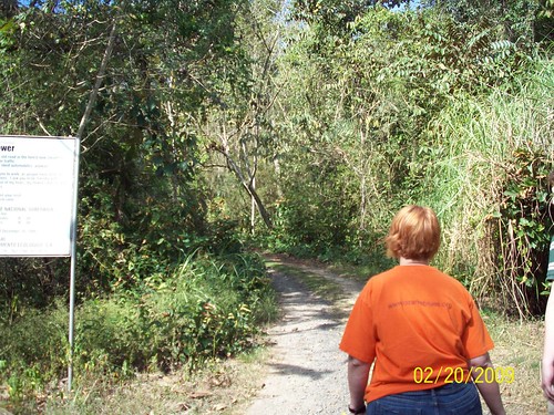
This posting is very interesting for those who wish to hike near Panama City; it was recently posted by Jerin on several of the Yahoo Panama Groups and he agreed to allow us to repost it. Thank you!
I have recently started exploring the areas around the city for things
to do in my limited free time. I love nature and the idea of being
away from it all, but I rarely have the time to get far away.
Although I have known about it since I moved here, I had not until
recently visited Soberania National Park. The park is only 20 minutes
from the city, yet you feel like you are worlds away. To get to the
main entrance of the park, take the road to Gamboa. Where you turn
left at Gamboa road, you will see the offices of the park. Here is a
map I made of the park and its trails:
http://www.flickr.com/photos/35971615@N07/3325598045/
Since I first went 3 weeks ago, I have been back every weekend. The trails are a
birdwatcher´s and nature lover´s paradise, and with the exception of
the Old Gamboa Road, all feature pristine rainforest. Here are some
great day trips you can make to the park.
Summit Zoo and Old Gamboa Road:
How to get there: At the entrance to the park, take a left on the
road to the Gamboa Rainforest Resort. While driving, look for the
signs that say Parque Zoologica Summit. Depending on how many people
are there, you can either park on the right hand side of the road next
to the gate or on the left side parking lot across the street.
What to do: The summit zoo is an aging zoo that has a good
representation of the wildlife and fauna of Panama. The zoo does have
a few modern exhibits for the harpy eagle and jaguar. The zoo is set
up in a park like way, including a bamboo road. Admission is $1.
After seeing the zoo, cross the road and next to the parking lot you
will see a small road crossing the railroad tracks. Cross the tracks
and walk (or drive) about 100 meters until you come to a T. To the
left you will see a gate with a Policia Nacional sign on it. Yes, you
can walk past the gate, and you will be on the Old Gamboa Road. This
is the old road that went to Gamboa (duh). The first things you will
see on the trail are the Summit Ponds, and the trail cuts right
between the ponds. We spotted some caiman, owls, and agouti near the
ponds. After the ponds you walk through some impressive bamboo growths
and some overgrown military installations. You can walk past that all
the way to the end of the trail, but there really isn´t much to see.
I recommend walking about 45 minutes and then turning around.
Compared to the other trails on my list, this one is not that
exciting, but it is very easy and if you are already at the zoo it is
worth the side trip.
What you need: Sunscreen, insect repellant , walking shoes. Shorts
are good for the zoo and should be OK for the Old Gamboa Road, but
long pants are always better.
Photos I took:
Plantation Road:
How to get there: At the entrance to the park, take a left towards
the Gamboa Rainforest Resort. Drive for about 5 minutes and you will
see a sign that says Camino de Plantación 500 metres. This is also
the entrance to the Canopy Tower. Turn right at the entrance, and
then turn left to the entrance of the trail. There is space for
parking here. You will see signs with a history of the trail, and
also a sign that says entrance is $3. Nobody is ever there to take
the money, so don´t expect to pay it, even if you wanted to.
What to do: During the construction of the Canal a three mile
improved road was constructed from the town of Empire to the Las
Cascadas Plantation. This was the first paved road in the interior of
Panama. This trail is the remnant of the Plantation Road and along it
you may still find remnant Cocoa, Rubber Trees and Coffee Plants.
(according to the sign) Less than 400 meters into the trail, you will
see an amazing waterfall. The trail itself go for about 3.5 miles,
and is definitely worth the hike. Right after it passes the old
plantation, it ends at the Camino de Cruces. At this intersection is
a bamboo station which is a perfect spot to eat a sack lunch. After
you reach the end of the trail you can either return via the
Plantation Road, or turn right on the Camino de Cruces and follow it
to Madden Road. The Camino de Cruces (see below) is a very difficult
trail and should only be attempted by those who are well prepared and
experienced in hiking. The plantation road however, is a well defined
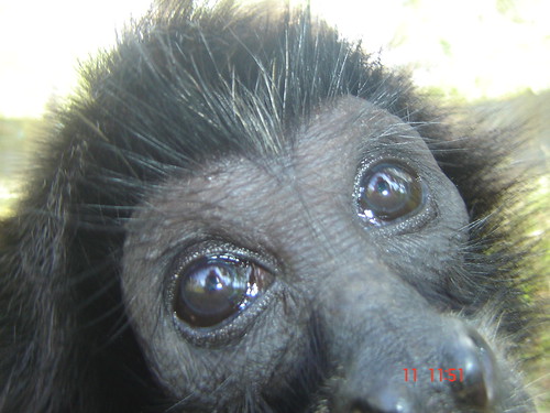
and an easy walk with a few moderate hills. We spotted some monkeys,
motmots, agouti, and iguanas. If anyone is interested in hiking this
or any of the trails and would like some help, please contact me,
6733-0657, and I will give you more information or guide you.
What you need: Good walking shoes, long pants, sunscreen (although
almost all of the trail is shaded by trees), insect repellant, and water.
Photos I took:
El Charco Trail:
How to get there: At the entrance to the park, take a left towards
the Gamboa Rainforest Resort. Drive for about 7 minutes and look for
a sign that says Sendero El Charco, 500 metros. Turn right into the
parking area. You will see many signs and the entrance to the trail.
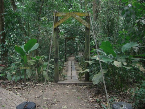
What to do: The El Charco trail is the shortest and most accessible
trail in the park. It is a very short (less than a mile) circular
trail with many bridges and educational signs along the way. With the
exception of a short uphill walk, the trail is flat and very easy to
walk. Near the entrance to the trail, a totally paved path leads down
to a waterfall with a swimming hole and covered picnic area. Here you
find restrooms and BBQ pits. Although the trail is short and flat,
you will see pristine rainforest and lots animals. We saw monkeys,
agouti, and an amazing large orange and blue bird that we couldn´t
identify or take a picture of as it flew across our path.
What you need: Walking shoes, insect repellant, picnic supplies, and
swimsuit. Shorts are OK for the trail, but long pants are always better.
Photos I took:
Camino de Cruces:
How to get there: At the entrance to the park, take a left towards
the Gamboa Rainforest Resort. You can either enter at the Plantation
Road (see above) and meet the trail at the bamboo station and walk the
last half towards Madden Road, or you can walk the whole section from
Cruce de Ventas. To reach Cruce de Ventas, follow the Gamboa road all
the way until just before the Chagres bridge. You will see a little
Marina on the right hand side before the bridge. Park your car there
and ask the men at the marina to take you to Cruce de Ventas. You
should not pay any more than $5 per person to get to the start of the
trail. If you use the marina at Gamboa Rainforest Resort, expect to
pay a lot more. It is best to take two cars, and park one at each end
of the trail. To get to the Madden Road entrance of the trail, go to
the entrance of the park, but keep going straight towards Chilibre.
Look for a sign that says Camino de Cruces, 500 metros. You can park
one car here to have when you get done with the trail. Another option
is to hike from Cruce de Ventas, and turn right at the bamboo station
onto the Plantation Road.
What to do: Be very careful, the Camino de Cruces is a very difficult
and long (6.5miles) hike. You should only attempt this trail if you
have lots of water and are prepared to climb over fallen trees, walk
across rivers, and do intense uphill walking. The Camino de Cruces
is the old road the Spanish used to carry gold from Panama City to the
Chagres River for transport to Portobello. A good history of the
trail is here:
http://www.bruceruiz.net/PanamaHistory/el_camino_real.htm.
Along most
parts of the trail you can still see the cobblestone laid 500 years
ago by the 4,000 Indian slaves used to make the road. At the ruins of
Cruce de Ventas, there are many signs telling you of the history of
the town and trail. Once you get on the trail, follow the pink and
orange ribbons that mark the trail. At many points the trail splits
into its dry and wet season routes. Be careful as sometimes one of
the ways is blocked by impassable fallen trees. As a rule, I always
take the routes to the right. At some points the trail can get hard
to follow, so always be on the lookout for the pink and orange
ribbons. Look for the bamboo trail which is the halfway point and a
great area for resting and eating. This trail is difficult, yet very
rewarding. Please take great caution when hiking this route. Along
the trail, we spotted howler monkeys, iguanas, agouti, and many
amazing birds and flowers. If anyone is interested in hiking this or
any of the trails and would like some help, please contact me,
6733-0657, and I will give you more information or guide you.
What you need: Backpack, lots of water, sack lunch, waterproof hiking
boots, long sleeve shirt and long pants, insect repellant, and
sunscreen (although almost all of the trail is shaded by trees).
Photos I took: